
- Other
- Other industries
- Technical information
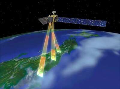
PRISM Observation
Three Independent Optical Systems for Viewing Nadir, Forward and Backward Producing a Stereoscopic Image
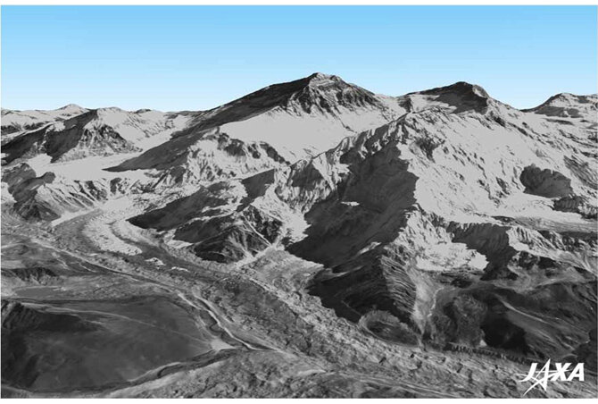
Digital 3D map: Can be used for various purposes
The Japan Aerospace Exploration Agency (JAXA) is starting to process the precise
global digital 3D map using some 3 million data images acquired by the Advanced
Land Observing Satellite "DAICHI" (ALOS).
The digital 3D map to be compiled this time has the world's best precision of five meters in spatial resolution with five meters height accuracy that enables us to express land terrain all over the world. Hence its strong character will prove useful in various areas including mapping, damage prediction of a natural disaster, water resource research etc.
Background: For information maintenance and disaster prevention applications
Advanced Land Observing Satellite "Daichi" (ALOS)
The needs for geographic spatial information are increasing all over the world to organize basic map information and prepare for disasters such as tsunamis and floods, etc.
3D maps are essential for organizing geographic spatial information, but, to date, manpower and airplanes were required to compile 3D maps thus such processes were limited due to cost and time constraints. The satellite DAICHI* mainly observed land areas all over the globe, but organizing its data to cover such broad areas has stalled due to the constraints of some challenges and the computation ability for automation in 3D mapping technology.
* The Advanced Land Observing Satellite "DAICHI" (ALOS) was launched in January 2006 by JAXA and was used in mission operations for five years and four months till May 2011. It observed various conditions of the Earth till the completion of its operations.
POINTS USING ALOS
Panchromatic stereoscopic sensor (PRISM)
The Advanced Land Observing Satellite "DAICHI" (ALOS) was launched in January 2006 by JAXA and was used in mission operations for five years and four months till May 2011. It observed various conditions of the Earth till the completion of its operations.
©JAXA
Effect: World's first "fineness of horizontal resolution" and "height accuracy"
The DEM of the digital 3D map to be processed by JAXA will express land undulations all over world with the precision of five meters of spatial resolution (and 2.5 meters for ortho-rectified images) with five meters of height accuracy by utilizing about 3 million data images that are less cloud cover acquired by PRISM aboard "DAICHI". The low-resolution digital elevation model released by JAXA is planned to have a horizontal resolution of 30 m and a height accuracy of 5 m (standard deviation).
Organization:
JAXA

