
- ALOS-2
- Other
- Other information
ALOS-2 Tips
ALOS-2 Product Parameter Setting for Archived Data
ALOS-2 archived data can be purchased from the online PLATFORM of PASCO. When purchasing data, you need to specify the processing level and parameters of the product.
This article introduces the selectable product processing levels, their respective processing contents and characteristics, and how to set parameters in the PLATFORM.
Description of PALSAR-2 Product Processing Levels
Four processing levels can be selected for ALOS-2 archived images, from Level 1.1 to Level 3.1. After specifying the scene ID, you need to set processing level for each scene ID. The table below shows the processing content at each processing level.
| Level | Description | Format |
|---|---|---|
| Level 1.1 | ■Definition:This is a complex number data on the slant range following compression of the range and azimuth. As one-look data, it includes phase information and serves the basis for post-processing. In wide-area mode, image files are created for each scan.■Tips:Suitable for InSAR analysis | CEOS SAR/GeoTIFF |
| Level 1.5 | ■Definition:This is a multi-look data on the slant range from map projection amplitude data, with range and azimuth compressed.■Tips:Can be displayed by the GIS or Remote Sensing software, but the image and map are misaligned because it is not orthorectified. Geometric correction is required by a user. | CEOS SAR/GeoTIFF |
| Level 2.1 | ■Definition:Geometrically corrected (orthorectified) data using the digital elevation data from Level 1.1.■Tips:This is suitable for an easy understanding since the images overlap on the map. During orthorectified processing, images are distorted at higher elevations, which may affect the analysis results. | CEOS SAR/GeoTIFF |
| Level 3.1 | ■Definition:Image quality-corrected (noise reduction, dynamic range compressed) data from Level 1.5.■Tips:Can be displayed by the GIS or Remote Sensing software, but the image and map are misaligned because it is not orthorectified. Geometric correction is required by a user. | CEOS SAR/GeoTIFF |
Features of PALSAR-2 Product Processing Level
| Level 1.1 | Level 1.5 | Level 2.1 | Level 3.1 | |
|---|---|---|---|---|
| Single look azimuth compressed | ||||
| Multi-look azimuth compressed |
||||
| Phase data | ||||
| Amplitude data | ||||
| Orthorectification | ||||
| Image quality corrections (noise reduction) |
||||
| Image quality corrections (dynamic range compression) |
||||
| Remarks | Single Look Complex (SLC) data and Interferometry (InSAR) processing. | Pixel spacing is selectable depending on observation modes. | Pixel spacing is selectable depending on observation modes. |
Product Parameter Setting
When you select a processing level in PLATFORM, the required parameters are automatically displayed.The table below lists the items that need to be set for each processing level.
| Level 1.1 | Level 1.5 | Level 2.1 | Level 3.1 | |
|---|---|---|---|---|
| Orbit Accuracy | Most accurate and available/Fixed orbit ephemeris (precise ephemeris) | Most accurate and available/Fixed orbit ephemeris (precise ephemeris) | Most accurate and available/Fixed orbit ephemeris (precise ephemeris) | Most accurate and available/Fixed orbit ephemeris (precise ephemeris) |
| Processing method(only ScanSAR) | Burst/Full-Aperture | |||
| Format(only CEOS for ScanSAR) | CEOS/GeoTIFF | CEOS/GeoTIFF | CEOS/GeoTIFF | CEOS/GeoTIFF |
| Scene shift | -5~4 | -5~4 | -5~4 | -5~4 |
| Resampling method | NN/CC/BL | NN/CC/BL | NN/CC/BL | |
| Framing | Geo-reference/Geo-coded | only Geo-coded | Geo-reference/Geo-coded | |
| Map projection | UTM/PS/LCC/MER | UTM/PS | UTM/PS/LCC/MER | |
| Map projection(Detail Item) | (e.g. Zone number at the center of scene) | (e.g. Zone number at the center of scene) | (e.g. Zone number at the center of scene) | |
| Pixel spacing | ||||
| Use DEM default flag |
〇:Settings required ー:No setting required
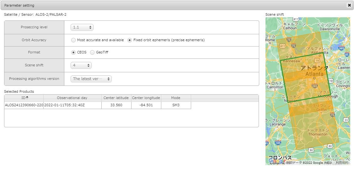
The parameter setting screen for Level 1.1 appears on the PLATFORM as follows.
■Level 1.1
Enquiries about purchasing ALOS-2 archived data can be made here.

