
- ALOS-2
- Natural disaster
- Technical information
ALOS-2 Sample Data
InSAR Analysis of the Vegetation Area - Earthquake of Eastern Taiwan in September 2022 -
On September 18, 2022, a Mw6.9* (according to the USGS) earthquake jolted the eastern part of Taiwan. Around Taitung County, where the epicenter was located, the earthquake caused extensive damage, including collapsed buildings, derailed trains, and landslides in the mountainous areas.
This article presents the results of Interferometric SAR (InSAR) analysis and phase difference analysis conducted by PASCO using ALOS-2 and Sentinel-1 data observed pre- and post-earthquake around Taitung County.
*Mw:Moment magnitude. The magnitude of the earthquake itself, considering the magnitude of fault movement at the epicenter.
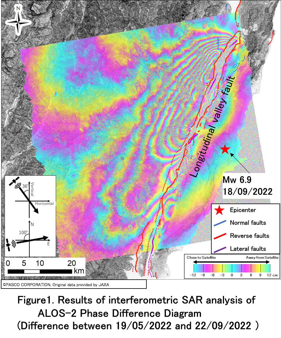
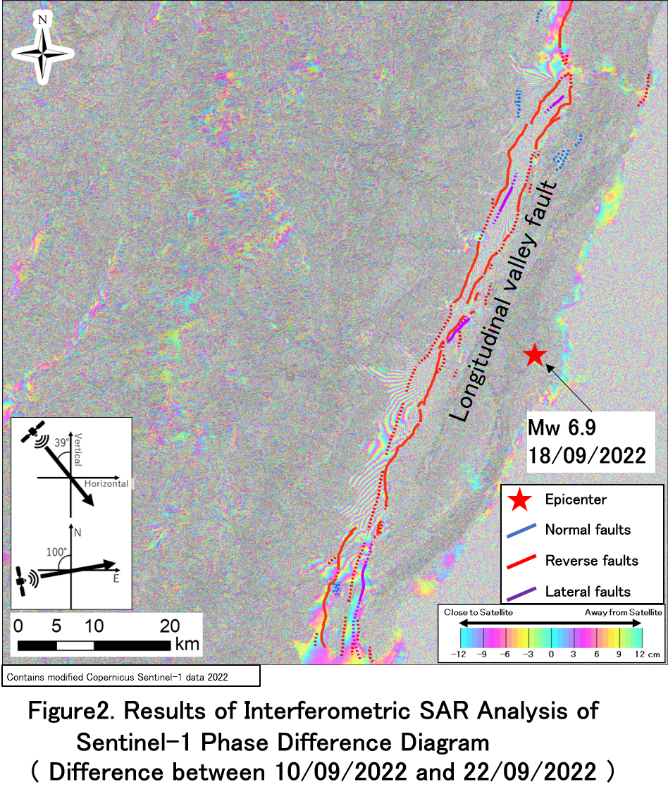
 In Figure 1, the results of ALOS-2 InSAR analysis indicate that the displacement was observed along the Longitudinal Valley Fault (Shyu et al., 2005)**. On the other hand, the InSAR analysis of Sentinel-1 data resulted partial interferometric area and does not show any significant wide-area variations (Figure 2).
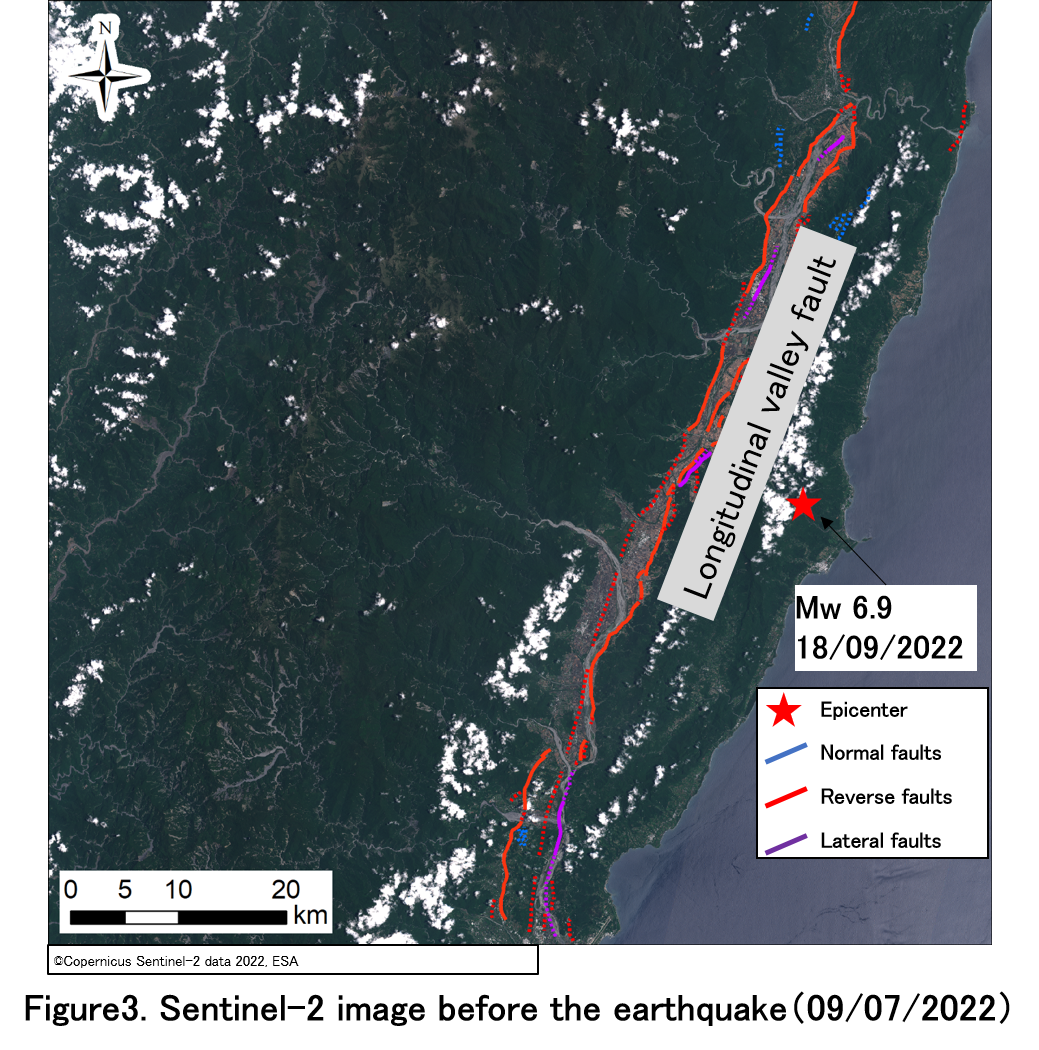
In the Sentinel-2 pre-earthquake satellite image (Figure 3), there is a difference in the distribution of non-interferometric areas in the vegetation area. This is due to the fact that the L-band wavelength of ALOS-2 can reach to the ground by penetrating through vegetation and it has potential to acquire information from ground surface.
Change analysis of 2 periods
【InSAR analysis results for ALOS-2 and Sentinel-1】 We analyzed the following area. In Figure 1, the results of ALOS-2 InSAR analysis indicate that the displacement was observed along the Longitudinal Valley Fault (Shyu et al., 2005)**. On the other hand, the InSAR analysis of Sentinel-1 data resulted partial interferometric area and does not show any significant wide-area variations (Figure 2).
|
|
 **Refer Shyu et al., 2005, for the fault locations. Shyu, J.B.H., Sieh, K., Chen, Y.G., Liu, C.S. Neotectonic architecture of Taiwan and its implications for future large earthquakes. J. Geophys. Res. Solid Earth 2005, 1–33. https://doi.org/10.1029/2004JB003251.
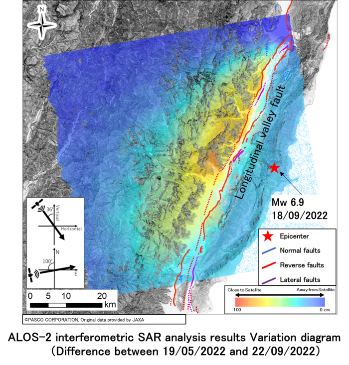
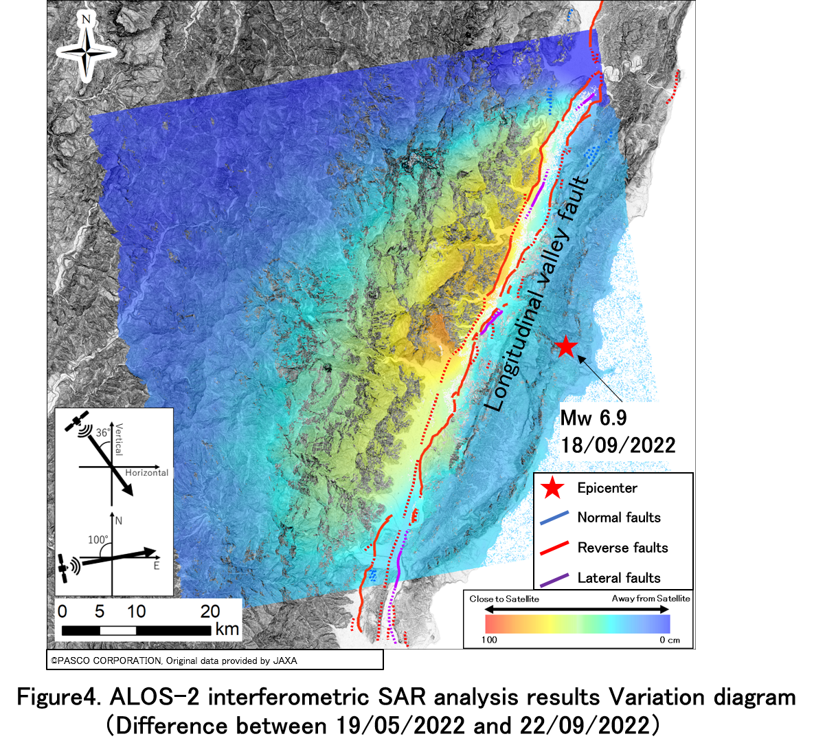
【InSAR analysis results for ALOS-2 (Variation diagram)】
Since the ALOS-2 InSAR analysis displacement result is data with wrapped phase difference of 360 degrees, the displacement value on the ground cannot be determined. Therefore, we converted the wrapped phase difference data into the displacement data by performing phase unwrapping (PU) technique.
As shown in Figure 4, a displacement (left lateral displacement or western upthrust) of up to 100 cm in the direction approaching toward the satellite was confirmed and noticeable on the west side of the Longitudinal Valley Fault.
**Refer Shyu et al., 2005, for the fault locations. Shyu, J.B.H., Sieh, K., Chen, Y.G., Liu, C.S. Neotectonic architecture of Taiwan and its implications for future large earthquakes. J. Geophys. Res. Solid Earth 2005, 1–33. https://doi.org/10.1029/2004JB003251.
【InSAR analysis results for ALOS-2 (Variation diagram)】
Since the ALOS-2 InSAR analysis displacement result is data with wrapped phase difference of 360 degrees, the displacement value on the ground cannot be determined. Therefore, we converted the wrapped phase difference data into the displacement data by performing phase unwrapping (PU) technique.
As shown in Figure 4, a displacement (left lateral displacement or western upthrust) of up to 100 cm in the direction approaching toward the satellite was confirmed and noticeable on the west side of the Longitudinal Valley Fault.
 Details of the images used for this analysis are as follows.
■ ALOS-2 imageries specifications
Observation date:19/05/2022 and 22/09/2022
Observation mode:StripMap (SM3)
Resolution:10m
Polarization:HH+HV
Off-nadir Angle:32.5°
Beam ID:F2-6
Scene ID:ALOS2431380450-220519、ALOS2450010450-220922
■ ALOS-2 Product processing level and parameters
Processing level : Level1.1
Orbit accuracy:Fixed orbit
Image format:CEOS
Scene shift:1 (northward)
Details of the images used for this analysis are as follows.
■ ALOS-2 imageries specifications
Observation date:19/05/2022 and 22/09/2022
Observation mode:StripMap (SM3)
Resolution:10m
Polarization:HH+HV
Off-nadir Angle:32.5°
Beam ID:F2-6
Scene ID:ALOS2431380450-220519、ALOS2450010450-220922
■ ALOS-2 Product processing level and parameters
Processing level : Level1.1
Orbit accuracy:Fixed orbit
Image format:CEOS
Scene shift:1 (northward)
If you are interested in the above two ALOS-2 scenes (pre-analysis images), we can provide them as sample images. Please enter "Taiwan Earthquake Sample Request" in the Inquiry details field and submit your request via the Inquiry Page.

