PASCO Satellite Ortho (PSO)
Overview
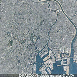
PSO product is a 2.5m color ortho image processed by pan-sharpening of cloud-free images observed by the Earth Observation Satellite “DAICHI” (ALOS) from 2006 to 2011.
It corrects the distortion of the unprocessed image by orthorectification processing the entire area for geometric correction.
The data consists of spatial coordinates (location) and can be easily superimposed with data already in the customer's Geographic information System (GIS) such as ArcGIS.
The PSO can be delivered in a data format or projected coordinate system according to the customer's needs and applications.
In addition to PSO images of the entire Japan, the images of Thailand are also available.
Specifications
| GSD | 2.5m |
|---|---|
| Band | 3 bands (True color) |
| Data format | GeoTiff |
| Delivery | DVD-R |
| Coordinate system | WGS84 series, UTM each zone |
| Covered area | Japan, Thailand |
Sample Image